
Latest Version
Version
1.48.4
1.48.4
Update
September 25, 2025
September 25, 2025
Developer
EANS
EANS
Categories
Travel & Local
Travel & Local
Platforms
Android
Android
Downloads
0
0
License
Free
Free
Package Name
ee.eans.utm.prod
ee.eans.utm.prod
Report
Report a Problem
Report a Problem
More About Estonian Drone Map
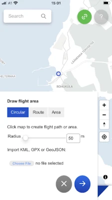
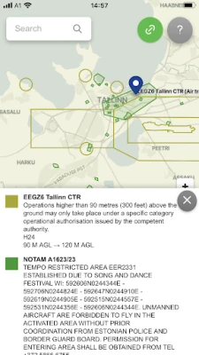
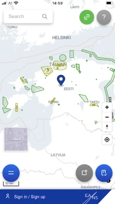
Estonian Drone Map is the official UTM solution from Estonian Air Navigation Services. The application allows you to see the rules for flying in Estonia, plan your flights and coordinate them with the air navigation service provider, if necessary.
The current app version:
• Displays all the temporary and permanent restriction areas, including UAS geozones and NOTAM's
• Allows the pilot to plan their flights and submit flight plans (not mandatory for open category flights)
• Ask the ANSP for mandatory take-off clearance near helicopter pads and for specific category flights
Rate the App
Add Comment & Review
User Reviews
Based on 0 reviews
No reviews added yet.
Comments will not be approved to be posted if they are SPAM, abusive, off-topic, use profanity, contain a personal attack, or promote hate of any kind.


More »

Popular Apps

Fetch: America’s Rewards AppFetch Rewards
Microsoft 365 CopilotMicrosoft Corporation
Clark's Pump-N-ShopRovertown
True or False Factschebdev

Spiky - Truth or Dare GameChouic

BBFit AZIgnite Engagement

Rozee Job SearchNaseeb Online Services (Pvt) Ltd

Duolingo: Language LessonsDuolingo

Harbiz ManagerHarbiz

IslamOne - Quran & Hadith AppUsmanPervez
More »
Editor's Choice

Do You Really Want to Know 2Gamtropy Co., Ltd.
Clark's Pump-N-ShopRovertown

Keeple - Absence Managementn2jsoft

Mes Congés et Absences110ms

Prayer Mode: Auto Silent + SMSAbrar Mehraj

Lawsuit The Unique Case FinderLevons Technologies Pvt. Ltd.
LAW in ONE: Pocket Guide 4 LawMyNaNi's

InstagramInstagram

Gangstar New OrleansGameloft SE

Star Wars™: Galaxy of HeroesELECTRONIC ARTS